
“There’s a razors edge
. . . . between genius and madness.
That’s a sharp,
. . . . hard edge to ride.”— Barry Blanchard
— top high-risk Alpinist
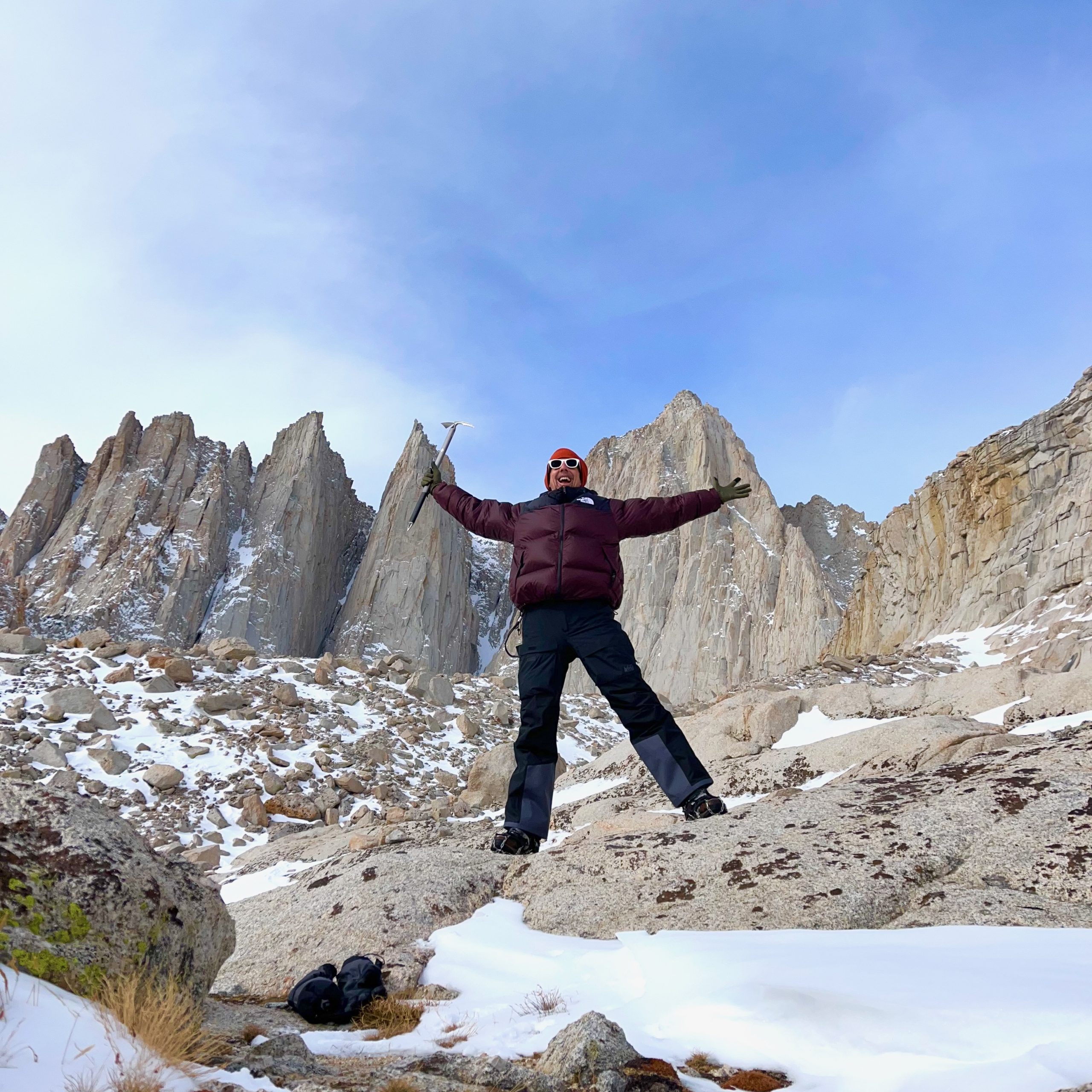
This is a story about one human summiting and descending one mountain. In this case, the human is me. I am an acrobat, athlete, amateur climber and all around adventurer. The mountain is Mount Whitney. Whitney is the highest peak in the continental US, standing quite tall and proud at a respectable 14,498 feet. Technically, I think this is called something like a “Free Solo Ascent of the Mount Whitney Mountaineers Route, Winter Season.”
UPDATE 2025: After 40+ years of extensive backpacking, including Rocky Mountain National Park, this was my first true “alpinist” mission… in the winter, at altitude, requiring an axe and crampons. It was a near disaster, as you will read. Since then, I have returned to the Whitney Mountaineers Route 5 more times, two of those resulting in summits. Me and Whitney are one much better terms these days. Want to join me on the next adventure? Start here.
NOTE: This is a really long post. You can just read the summary.
INTRODUCTION
A reckless adventurer takes a crash course on mountaineering.
What I thought of as an ambitious hike turned into the adventure of a lifetime. A lot of wild adventures happened between the trailhead and the summit (and back again). This is my attempt to convey the reality, both for “armchair adventurers” who have no intention of ever summiting, and for those brave and foolish enough to attempt a similar feat themselves.
To start, I should sat, this ended up (unexpectedly) to be the hardest single thing I’ve ever done in my life. The endeavor pushed me far beyond every physical and endurance limit I ever imagined I possessed — and as someone who has completed both a marathon and an Iron Man 70.3 triathlon, those are high limits. By the time I had arrived back to the trailhead, I had been hiking, scrambling, ice-climbing and bouldering continuously non-stop for 26 hours. Starting out from camp at 8am Friday: all day, all night, and well into Saturday morning.
(note to experienced mountaineers: Yes, I have heard of the “Alpine Start,” getting up well before dawn to safely bag a summit and descend. But I was not thinking of the descent; I had a singular goal: to reach the summit. After that, I figured it would all just work itself out naturally, no problem. I was half right.)
A few things to note while reading:
- I chose to (mostly) fast during this adventure, limiting my caloric intake to roughly 600 calories a day. My ostensible reason was to save pack weight (food is so heavy). On reflection, I think the real reason was that I just wanted it to be a more extreme experience. I succeeded on both counts.
- My route ended up being the full “Whitney Circuit,” which is up Whitney via the Mountaineers Route, and down the Whitney Trail. For the first half of the trek (Portal Trailhead to Upper Boy Scout Lake), I hauled a pack weighing in at 55 pounds on the Viking scale. That was too much. For the remainder of the trek (and return to trailhead), I carried a 12 pound daypack, which was mostly water and a weatherproof parka.
- I thought I was prepared for Whitney. I am an athlete and in very good shape. I was not at all prepared. A wiser human would have trained on a few less challenging high altitude mountaineering routes to build skills and confidence and endurance prior to a major trek like Whitney. I got home alive (and uninjured!) by the grace of God. Whitney taught me some lessons.
- This is a long story, full of details. I hope you enjoy it.
- I had never used an ice-axe before in my life. I got hold of a discount Black Diamond Raven on eBay, and watched both The Alpinist (2021) and several tutorial videos on REI, mostly demonstrating self-arrest and glissade techniques.

Ever since I found out that Mount Whitney, the highest mountain in the continental united states, was a mere 4 hours north of me, I knew I had to summit it. There are two acknowledged routes to the top of Whitney: the “Whitney Trail,” an 11 mile classic alpine hike, and the “Mountaineer’s Route,” a significantly more challenging and somewhat technical route up some very steep ice slopes and bouldering routes to the top.
Of course, I had to do the Mountaineers Route. Of course, I am impatient, so no matter that it was the middle of winter, there had just been a massive snow storm, and temps dropped to below -20° F on the summit. It was only a mountain. I’d climbed mountains before. Hell, I’d camped on top of the Continental Divide without a tent. I was prepared. Or so I thought.
My Whitney Circuit: the Map
I realised in relating this story to friends and family that it gets confusing. I actually made this map just to communicate to them the sequence of events, and to answer such questions as: “Why didn’t you call us when you made it to the car?” (A: I lost my phone), “Why didn’t you go back for your phone?” (A: I did, it was deeply buried), “Wait, you left your gear on the mountain?” (A: Yes, it was 4 miles and 3,000 vertical feet on the other side of the circuit, and I was beyond exhausted after 26 continuous hours of non-stop climbing/downclimbing)
So, here’s the map. Follow the numbers:

My Adventure: The Short Story
Just in case you don’t care to read all my deep ruminations on the meaning of all this, I’ve summarized the entire adventure in a few paragraphs for you, right here:
Set forth on the Whitney Mountaineers Route solo at sunrise on Thurs Jan 18. Didn’t really know what I was in for. Weather was beautiful – partially cloudy and zero wind, maybe 30° F. With exertion, stripped down to thermals within the first mile. Thought I might summit the first day. That was not to happen. Ended up setting up camp well after dark at Upper Boy Scout Lake, totally exhausted after 10h of continuous hiking, climbing, backtracking, and trail cutting through powder with a 55-lb pack. No trail markers were in evidence at all, and most of route was totally covered in snow with deep drifts between large boulders. Hard going, to be sure.
Friday 1/19: Started out bright and early the next morning at 8am. Carried only ice axe and microspikes, and left everything at camp other than two 1L nalgenes and a parka. Fast and Light. Slamming for summit. The couloir was seriously challenging for me: 400′ of ice, 400′ of loose snow (hardest), and 400′ of very loose scree (several rockfalls). Finally made it into the Notch just before sunset… view was utterly breathtaking, seeing forever, 100+ mile sight lines to both the east and the west.
The final 400′ bouldering / climbing section was difficult, because I intentionally chose challenging routes. But I got caught in overhang / dyno situations twice, which i didn’t like with gloves and 200′ of fall exposure, so I had to downclimb twice, which was quite nasty. And the sun was setting. BTW, the “easy traverse” (1/4 mile to the east, switchback to the west) was utterly impassable, fully filled and covered with loose snow + ice sloped at roughly 50°. so scramble / boulder / free climb up was the only viable option.
Summited an hour after sunset, and that’s when all hell broke loose. Black clouds rolled in, sky went dark, winds picked up to around 40-50mph gusts, and it started snowing fairly hard. I had finished my first litre of water and opened the second to power up before descent. It was frozen solid. I hammered at it for a minute with the ice axe and was able to extract about 4 oz of liquid through the punched hole. That was that. Oh well.
I decided that the Mountaineers Route was too dangerous to do downclimbing in the dark and snow, so I thought I’d make an easy evening of it and return via the Hiking Trail, theoretically — in my mind — getting back to the trailhead around midnight. I departed the summit with confidence and a pep in my step.
“Man makes his plans,
and God laughs.”
— Proverbs 16:9
The Muir ridgeline trail in a blizzard was horrendous. The entire trail was 12-30″ deep with powder, and high winds stung my face. I slogged though it for what felt like miles. It took me a solid 5 hours to get anywhere near the “Ridge Crest”, where I had begun fantasizing that I would hop over the ridgeline and descend into a gentle pine forest, sheltered from the hurricane gusts and pelting snow. That was not to be.
As I got to the fully exposed ridge, the wind picked up severely. And looking over the edge, all I saw was snow, miles and miles of snow. Not a tree in sight. I followed the fully exposed ridgeline for 100 feet or so, backtracked several times in vain searching for the trail down, and then, studying the topo and seeing the “99 switchbacks”, just said “fuck it.”

I jumped over the edge and began one of the most awesome, gleeful glissades ever. I’m pretty sure I covered about 1,500 vertical feet inside of 10 minutes. It was wonderful. What followed for the next 12 hours was not as wonderful.
I found the “trail” perhaps a dozen times during the course of the night, as I stumbled through snow, downclimbed, and jumped off small cliffs, praying for safe landings. 80% of the path was totally covered in snow, unreadable, visibility was about 100 feet, and I ended up just slogging through dense forest and steep ravine for countless miles.
Well after sunrise, around 10am, I saw my first sign of civilization, some pipe across the stream, and an hour later, I stumbled into the family campground at Whitney Portal… a solid mile east of where the “trail” supposedly ran.
It was a long long long dark night and I would not repeat it in a like manner. Quick ice axe skills and a death grip on its shaft saved my life more times than I can count. In particular one sweet glissade transitioned to ice approx. 300 feet downslope, and my speed went from 5mph to about 25 mph in a matter of seconds.
I self-arrested for all my might, but it still took a good 30 feet to get purchase. And at the end of that, I was stranded on a steep ice slope in a snowstorm, with a sharp rock cliff 30 feet below me. Eventually I jumped off the cliff. Lucky for me, I landed face first in six feet of powder.
God bless. That’s the summary.
* * *
The rest of this post expounds upon that summary with detailed micro-stories and my interpretation of lessons learned from that harrowing climb and night on the angry mountainside.
PS – in case you are wondering, yes: Whitney is a woman.
Expert Mountaineers know when… to Turn Around?
In my initial “planning” for this trip, I thought that I was prepared to make rational, sober decisions, and to turn around if it became necessary. You know, like “smart” climbers do.
But that’s where my mouth (and stubborn-ness) got me into a little trouble. I had invited my most adventurous and physically skilled friends to come along with me, including former American Ninja Warrior Travis Brewer. Travis told me : “Don’t be afraid to turn around, if that seems like the right thing to do. Whitney’s dangerous, especially in winter.” At first I started to thank him for the wisdom… and then my soul hijacked my mouth. My response?
“Dude, I’m getting to the top of that mountain, come hell or high water. One way or another, I’m getting to the top.”
And that sealed the deal. I am a man of my word.
I didn’t have the skills. I didn’t have the team. I didn’t have the energy. But I had the willpower. That’s really the only way I made it up — sheer iron will & determination — and faith & prayer.
What does it mean to “Respect the Mountain”?
It means, quite simply, the same thing that surfers mean when they say “respect the Ocean.” You might go an hour without a single surfable wave, you might have a hour of perfect sets, or you might get clobbered by a surprise monster wave. Likewise, Winter Whitney can be a pleasant, sunny, windless 35° — as it was for the start of my climb — or an angry, dark, snowblind fury of a blizzard with 50 mph wind gusts and 0° wind chill that turns your fingers completely numb within 30 seconds of coming out of the gloves — as she was for my entire 16 hour descent.
Those things are mostly out of your control. Mother Ocean — and harsh Mistress Mountain — wield much greater physical (indeed, primal) forces than any individual human. Surfing Mavericks or Climbing Whitney — you are putting your life in the hands of God.
And so, in short: Respect the Mountain.
Its the Mount Whitney Mountaineers Route… not a “Hike;” and not a “Trail”!
One of the primary misconceptions I had prior to departing (despite reading a bunch of travelogs detailing ice climbing and bouldering) was that this would be a hiking / backpacking trip up a well defined / groomed trail. That was about as far from the truth as can be. The Mountaineers Route is a raw, untamed mountain passage, with no trail markers of which to speak. Witness:
- This is not a “hiking” trip. I’ve hiked thousands of miles through both forests and alpine environments, and am utterly comfortable backpacking. This was some combination of trail cutting, ice climbing, bouldering, meditation, and extreme alpine ascent.
- This ascent / climb absolutely requires crampons and an ice axe. Not possible without those tools. Several steep slopes of solid ice to ascend / descend along route. And as we’ve noted in a previous post, downclimbing is 3x more challenging than climbing up.
- Correction: Until I got back and did some googling, I did not know the difference between crampons and micro-spikes. Turns out, I did this in soft leather “mid” height summer hiking boots, with a $12 set of micro-spikes strapped to the soles. They worked. One blew out of its rubber during the final 6 hours of descent, but that was past its requirement for life-saving friction.
I still think, especially for all the ice climbing, that legitimate crampons — with 1-2″ toe spikes — might have been a wiser & safer choice. Of course, legitimate crampons require legitimate mountaineering boots, with the rigid “heel welt” (locking groove) for solid crampon binding. So while my hiking boots (on clearance) and microspikes (Amazon) cost, in total, $72, a pro-set of mountaineering boots and crampons will set you back somewhere around $900 total ($700 boots, $200 crampons). But you truly have to consider: What is your life worth?
Post note: Deals can be found. Turns out there are plenty of wealthy people who get all their kit, try mountaineering once (or never), and then decide to pursue other recreations. I was able to pick up a used pair of La Sportiva Nepal EVO GTX mountaineering boots on eBay for just $210, in my size… that’s an amazing deal compared to the $699 + tax that they cost new. So, deals are available, do your research…
That stated, onto the main travelogue:
STAGE I : WHITNEY PORTAL TO UPPER BOY SCOUT LAKE
| route | Mount Whitney Mountaineers Route |
| altitude gain | +3,000 vertical feet |
| reported trail distance | 3.4 miles |
| actual hiked distance | 12.6 miles (track) |
| actual duration | 10 hours (8am to 6pm) |
| base camp location | ///worth.revisit.laudable |
It stated out easy enough
The start of the Mount Whitney Mountaineers Route is, in fact, the start of the Whitney (Hiking) Trail. They are one and the same, for the first 3/4 mile or so, a switchback or two. This part is, in fact, a groomed and maintained trail that traditional hikers and backpackers would recognize (as long as its not covered in snow).
About a mile in, the Trail splits off left and the Route goes right. Or rather, the Trail goes left and continues its lazy switchback zigzags up the mountain… the Route cuts straight into the forest and, pretty much, goes straight up (and continues that way, for about the next 6,000 vertical feet). You wander through a forest, you do some rock scrambles, you cross a few creeks back and forth. Not a huge deal.
However…
You notice one thing. With every 100′ gain in altitude, the snow gets about an inch deeper. And deeper. And deeper. In short order, there are no footprints.. there is barely a trail. You are “postholing” it (i.e. smashing through 12-24″ of fresh powder) with each footstep. This is quite a bit more energetic than normal hiking up a trail. This is called “cutting a trail.” Its work.
You finally cross the creek one last time, and despite your inclination to follow the creekline through the dense willows (a path that I hewed for a full hour before getting hopelessly mired in the branches), the actual consensus route is a near vertical rock climb up about 25′, which brings you to the notorious “e-Ledges”, or Ebersbacher Ledges, so named for the couple that first chose that navigation workaround, way back in ~1957-ish.
The First Crux
Even though I had read more than 8 accounts of ascents prior to departing, I did not recall reading that term. No matter. As the Mountaineers route climbs up the sidewall of the valley, which is a raw granite face, it kind of turns from a trail to a ledge. I am not certain that I was even on the trail, but I was following the signature tracks of my invisible buddy, who I had nicknamed “Texas Two-Toe.”
I called him this because he (she? no, it had to be a dude.) wore crampons with two very agressive front spikes that appeared to extend about 3cm from the toe of his boots, and looked like a bear stabbing the snow and ice with two claws on each paw. Since there are no trail markers to speak of (I witnessed, across 20 miles, no more than three pathetic little yardsticks sticking out of the ground, with some kind of cracked olive paint on their tips) , my primary trail guidance was following the marks of those two prongs.
So it was that those steps led me to a ledge. Quite a narrow ledge, in fact. About 3 inches wide. Worse, the entire foothold was coated in about 1/4″ of hard ice. I guess it was time to test these microspikes. I placed one foot forward, leaned as hard as I could into the wall (but there were no handholds, just smooth granite), and… freaked. I stepped backward. It was only an 8 foot stretch. What was my problem? I looked down.
Oh. There was my problem. A sketchy 3″ wide shelf coated with ice, with a 300 foot drop to the rocks below. In other words, slip and die. Probably less than a mile total into the trail, I very seriously considered turning around and going home right there and then. I was alone on this mountain — well, just me and Texas Two Toe. I had no one to share this with, no one with whom to compare risks. I had nothing to prove (or did I?). Grrrrrrr.
I sat there for a few minutes, calming my breathing, and made a decision. Fuck it. It was eight feet. 3 steps. I could do it. grit teeth, don’t look down, step confidently, go.
SIDENOTE: I faced this same exact crux, in two very different manifestations, twice more that same week. Read about that here.
I stepped. I estimated I had contact via 3 prongs of the 12 on my microspikes. I prayed to the Chinese Manufacturing Gods that their chains would stay strong and their rubber pliant. I stepped. I breathed. I stepped again. breathed. Cross step. and I was across. Back on a 24″ wide shelf-path. Safe. Standing tall. I had made it. My microspikes had made it. I whooped with celebration.
I had honestly not had any idea why I would need crampons before that moment. Now it all made total sense. Just as the hard tacky rubber on the toes of climbing (“ascent”) shoes allows climbers to “rub” the rock and find contact / grip / friction where there is none, so these spikes allow one to bite into the ice and gain security where normal shoes or skin would simply slide right off. I just had not imagined a sitch where only 2 or 3 little 1/2″ spikes punching into 1/4″ of ice would be all that was preventing me from falling into the abyss.
Well, now I knew. I kept hiking.
The snow got deeper.
Much deeper.
Is there actually even a Trail?
Short answer: For the Whitney Hiking Trail? Yes, Absolutely.
For the Mount Whitney Mountaineers Route? No, not really.
As stated previously, this is a “route” for Mountaineers and Adventurers. Not a trail. Upon my return, I decided to research this topic further. It was surprisingly a deeper debate than I had thought, with some precedent.
Turns out that there’s actually an active political debate involving both wilderness activists and the Park Service (NPS) regarding as to what formally constitutes “the trail” — thus the reason for the conspicuous lack of trail markers (there are indeed mini-cairns here and there — I built some myself — but those are as likely to be right on the GPS track as they are to be 300′ off it).
Seems that prior to the advent of GPS, the “Whitney Hiking Trail” was established and “well marked” and actively maintained by NPS… whereas the Mount Whitney Mountaineers Route was always considered just that: a scramble / “choose your own adventure” passage between about 8 key waypoints, loosely strung together in a vertical chain leading all the way up to the summit.
The spirit of the Mountaineer’s Route historically was: “You’re an adventurer, there are no fixed paths… figure it out on your own.” …but as GPS and smartphones (and then the AllTrails app) came online, and people being people, many found the urge to “establish” the “correct” track up. And so there is a GPS breadcrumb trail on the app, and maps, and…
Bottom line is: as of today (2024), there is no formal trail per se. Its just 8-ish waypoints, from the e-Ledges to Lower Boy Scout Lake to xyz to the Notch and so forth. So my constant quest of “finding the trail”… ESPECIALLY on that talus / scree slope above LBSL, was in fact quite humorous.
There is/was no trail. Just a destination.
Just like life itself. Go figure.
STAGE IIa : UBSL to the Notch
Total. Exhaustion. And Beyond.
“I never thought about the trip back.”
This paraquote from the classic sci-fi movie Gattaca (1997) pretty much sums up my attitude, and serves as my direct inspiration for completing very hard tasks. In this pivotal scene, two brothers compete. The natural born brother is competing with his genetically engineered (superhuman) sibling. Just as they did when they were children, they head straight out into the wild ocean at night, swimming to unknown distances. It is a very dangerous game of chicken. Whoever gives up first — or drowns — loses. Watch:
“You want to know
how I did it?
This is how I did it, Anton:
I never saved anything
for the swim back.”
So that’s how I did the Mount Whitney Mountaineers Route. I knew if I had to think about getting down, if I spent one iota of thought on that challenge, that it would only sap energy from the ascent — and this ascent was so severe, so extreme, that I needed every last microgram of energy and willpower to make it.
Watching this video again, it makes me realise that Ethan’s rationale, his mission, is to beat his brother at his own game. I wonder, in retrospect, how my own drama mirrors that. As a youngster, I always imagined myself a wild adventurer, in the vein of Luke Skywalker and Indiana Jones. But in reality, I was a very serious businessman, working my ass off, with no vacations. Meanwhile, my brother was sending me pictures like this:

So, why was I on Whitney? To learn something about life, to show men what is possible, or to compete with my brother? Perhaps, all three.
Back to our story:
I mean, I had already totally exhausted myself on day one — a part of me thought I could summit in a day (with a 50 pound pack?!? hahahahaha!!!) — I had made it barely halfway up, on a 10-hour non-stop climb. Clearly, it would take a minute to summit. I conservatively estimated I’d be up there in 4 hours. I set out at 8am. By noon, I had made it to Iceberg Lake — exactly half way from camp to summit. Yikes.
What I hadn’t accounted for — or more truly, had refused to acknowledge, is that God designed Whitney as an ever increasing series of climbing challenges. So each leg was harder than the prior. This held equally true for leg 2 (Upper Boy Scout to Iceberg), as leg 3 (Iceberg to Summit). So I was not to make it up in 4 more hours. Not at all.
What Exhaustion Looks Like
At one point on the ascent, the lower half of the couloir, I was very very very tired from the constant “bury ice axe in full shaft, kick in left foot hard, kick in right foot hard” rhythm. Each repetition moved me about another 24″ up the 1000 foot slope. I rested every 10 cycles, doing my breathing meditation. But about halfway up the slope, with about 500′ of tumble below me, I got very calm. Indeed, as I closed my eyes, resting my brow on my hands, I felt a deeeeep deep calm and peace. And…
I actually fell asleep. Right there on the mountain, my life resting on three points of contact in chunky powder. I woke up, opened my eyes, and had one of those “Where the fuck am I?!” moments — like when you wake up in the middle of the night in a hotel in a distant city. But this time, it wasn’t “safe in your hotel room”… this time, my astounding awakened response was: “Oh, I’m on a 45° snow slope at 13,500 feet, perched for dear life by the shaft of my ice axe and my two feet dug into loose snow …wait, was I just sleeping? What tha fuck???!?!?“
I resolved not to relax enough again that I fell asleep.. at least not until I was in a very secure place, preferably some place with a heater and a flat floor. But it made an impression on me. If I could fall asleep in that situation, in that position… I was tiiiiirrreeed.
STAGE IIb : SUMMIT
The Bouldering Problem
There are 2 alternatives to the final summit path of Whitney: a fairly challenging bouldering route, or an easy “traverse”, which is essentially a long cliffside path that goes 1/4 mile out at a gentle slope, then a 1/4 mile back to summit. 400 vertical feet either way: one is just straight up, and one is gentle.
I mentioned this to my hardy fellow alpinist Matt — that I might just opt for the “easy” traverse — and he just laughed. I was a bit confused. He saw the look on my face and clarified: “Dude, its the middle of winter. We just had a major snowstorm. That traverse is gonna be sketch as fuck, covered in snow. Do the bouldering. You can find a route.”
I mulled these words as I got closer, but in truth, I didn’t believe him. I figured I’d try a little bouldering, and if I was uncomfortable, I’d have the traverse as backup. I hadn’t read anything at all online about the traverse being “sketch” or “snow covered.” All published accounts only mentioned it as “super easy” and “the route to take when you are exhausted”
That all changed as I finally arrived at “the Notch”. After recovering from the awesome, utterly stunning beauty of the “other side of the Sierras”, I looked up. Saw the bouldering route. Looked doable enough. Then I searched for the traverse. Or rather, I thought, “Where the hell is the traverse?” And finally, I saw it:
On a completely white, snow covered mountainside, there was a one foot “indent” on the snow, lazily ascending away from me, then sharply cutting back, all the way to the top. In other words, Matt was completely correct: That was impassable. I would not be on a sheer cliffside, stomping my feet into powder, hoping to connect to an unseen rock ledge unknown feet below.
It was bouldering, or bust.
I tightened my pack straps, took 3 sips of water, visually chose a route, and started for the summit.
“If you need to remove the gloves…”
By the time I was on the bouldering route, the combination of dusk and altitude had brought the temperature down from a comfy 35° to a chilling 20°. So, naturally, i climbed in my gloves. Two gloves, actually: my inner silk liners, and my outer insulated Gore-Tex shells. Awesome for keeping the pinkies warm. Not so great for two-fingered micro grips on rock. Not that this should have mattered.
There are, of course, mapped “routes” up most walls, including full grip diagrams and suggested choreographies. In the outdoors (outside of gyms), I’ve had little interest in these. I much prefer to just look at a pile of rocks or wall, and just pick a route, and hit it. In my experience, in nature, the holds just appear, right when and where you need them.
I’ve 0ften felt, while climbing in nature, that rock walls and boulders are clever puzzles designed by God for our enjoyment, and they ask us to trust both the designer and ourselves: the designer in that they give you what you need to make it up the wall, and ourselves that we have, inherently, the skills and smarts to find and use the right holds to get us up there.
Of course, sometimes, just like in life, you get stuck. You get to a point where either you cannot even find a suitable hold for the next move, or the hold you find is simply too difficult to overcome the danger / risk. This danger / risk is also called “exposure”. Exposure as in, if you miss the hold or slip off the wall, how far will you fall, and how badly might you get hurt.
And so I looked, and studied, and picked what, to me at the time, seemed like an easy, yet mildly challenging and fun, route up the mountain. I did not think about exposures. I simply began. But looking at a route from below can sometimes be deceiving. You miss little details. You can’t see everything from the bottom. Some things you can only find out by actually being there.
This is how I got to my first “dead end,” about halfway up the 400′ wall. I should note that I was bouldering, without protection. As in, no ropes, just “scrambling / bouldering / free soloing” up the mountainside. I got to a point where the next hold would require a prayer — reaching up and hoping for a grip to appear, with no safe way to return. That did not seem like an acceptable risk. Slowly – carefully – I retreated about 20 feet back down. I studied the wall again.
I saw a route about 8 feet to my right that looked much easier. I traversed and began again. Made rapid progress up another 15′. Then there came a tricky little grip. It was strong, but it was too small for my gloves. It was a two-fingered nub, and I knew that in order for it to support my full body weight, I would need skin contact. But I had on these damn gloves. So there was nothing to it. I pulled off my gloves, very carefully, and, having only one free hand, placed them in my mouth. Hello? This should have been a sign!
Now, using my free (and rapidly freezing) fingers, I locked onto the grip and lifted myself up. Satisfied, I scanned for the next grip. And then there it was: the crux. In this case, the crux was in the form of an overhang… basically, where the next grip is past the vertical plane, where you reach up and backward so that you are hanging, and then do a full body pull-up to haul yourself over the edge. It was doable, for sure, but…
I did the first wise thing. I looked down to check my exposure. If there was no grip atop that overhang, or if I slipped on the attempt, what was the worst that could happen. Gloves in my mouth, hanging from two fingers, I looked down. The fall… would have been about 250′ to the rock below. Not good. Not good at all, in fact. I cursed. I was pissed. But I also realised that in no way shape or form should I have had my gloves off. If it required that much grip, alone on a mountain at 14,000 feet, then I should not be on that route.
Cursing loudly through gritted teeth on gloves, I carefully climbed down, again. Now I was mad — at both myself and the mountain. And now, too, the sun was setting. I knew I had to get to the summit before dark. My ego exhausted, it was time for humility. I prayed. I also decided that bragging rights were over, and no longer looked for a “suitably challenging” route up the wall. Already 150 feet up, I just wanted the easiest, fastest route at this point. And so, I studied, picked and prayed.
Gloves back on, route selected, I slipped into a mantra : “Thank you God, Thank you Jesus, Thank you YHWH.” I repeated it with every breath. It was gratitude, but also a request. A request to get me safely up the mountain. I had done all I could with my own power. To summit, I summoned supernatural powers. I asked God to help.
20 minutes later, I reached the plateau. I had made it. It wasn’t the summit, technically; the top of the bouldering route is about fifty feet shy of the summit. To get there, you walk / hike / hop across a strange otherworldly field of massive boulders and rock plates. But pragmatically and spiritually, the top of the boulder is the summit. I got on my knees, praised God, did a little dance and sang Hallelujah.
And then just about sprinted across those rock plates, the final 200 yards to the actual, technical summit: the USGS plate that marks the highest point in the continental USA.
The Summit: What Matters Most?
Once I got there, I was exhilarated. Also, though, suddenly, I felt more alone than I ever had, most of my life. I realised that I was standing at 14,500 feet, without another human anywhere for 20 miles in every direction. Just me. No one knew I was there. Why would anyone care? Why should I care? Why had I even done this?
Engaging in a wild hare, I took my phone off of airplane mode. I figured, I have clear line of sight to every cellphone tower in every direction for 100 miles, perhaps…?
Amazingly — miraculously — I got 4 bars. It was on! I called the three most important people in my life. Again — miraculously — each of them answered my call on the first ring. Looking back, I think I was absolutely manic. I was also sleep deprived, totally exhausted, malnourished, dehydrated, and utterly ecstatic that I had accomplished the task that I had set out to do: summit Whitney. I told each of them where I was, and how much I loved them. It was getting dark, the temperature was dropping, and the wind was picking up… so I made them short calls.
I told each of them that — not to worry — I had decided (quite spontaneously) to return via the “easy” route — the 12 mile hiking trail with plenty of switchbacks that is the most common route up and down Whitney. At first I said “I should be at trailhead by sunrise”, but then, my eternal optimism kicking in, I corrected myself: “No, that’s not right. I should be there by midnight. I can speed-hike it.”

At that point, God was most certainly laughing. Probably a full LMAO.
Did I mention that, as I celebrated with my fam, the temp was dropping? That was an understatement. What happened, was that Old Lady Whitney, Goddess of California, had flipped her bipolar switch on me. She and God had blessed me, for sure, giving me the absolute perfect conditions for ascent: zero wind, sunlight, and warmth (35° being, in fact, quite warm for Whitney in the winter).
Now that she had given me my gift, she demanded payment. She decided to show me just how pissed off she was. And when a mountain gets pissed at you? Look out.
The Shift: From Paradise to Hellscape
Within thirty minutes, four things happened:
- It got dark
- The winds kicked up to 20mph, 40mph gusts.
- The temp dropped from about 25° to 5° F, and…
- It started snowing.
I realised, quite suddenly, that I was in… a situation. I was all alone, at 14,500 feet, in the middle of a snowstorm. I had to get myself down from that mountain, fast. And I had not looked at the map. Did I mention previously that Whitney is all about not marking the trails?
Having finished my 1 litre of water on the way up, I figured pre-descent was the perfect time to start on liter two. The lid was frozen shut. Urgh. But I forced it open. Tilted the bottle, and… nothing. WTF? I looked. There was a very solid plug of ice sealing my bottle. Both annoyed and amused, I did what any neanderthal who had just scaled a mighty mountain would: I took out my ice axe and hammered the hell out of that ice plug.
Eventually, I was able to carve a small hole in the middle. Victorious, I tilted the bottle. Slowly, ever so slowly, about 3 ounces of water leaked out. And that was it. I was now carrying a solid 0.9L block of ice encased in Nalgene. Oh well.
At this point, I was laughing too. What else can you do?
OH, there was one other thing I could do: Layer Up. Thank GOD, I had had the intuition to pack my insulated parka. Having not needed it the entire trip, I had debated whether it should have made my daypack or not. THANK GOD, I packed it. Gleefully, I put it on now. That was Six Layers: tech t-shirt, tech longsleeve, polypro undergarmet, Gore-Tex bib, heavy down jacket (TNF Nuptse, FTW!), and parka.
I was, in fact, snugly warm. The previous night I had dreamt that my sleeping bag had transformed into my parka. That was funny. Because I actually could have just rolled up and gone to sleep. Cold upon awakening, perhaps, but alive. But I thought, no, that’s a bum choice. I can make it down. I checked my AllTrails, tried to get some vague sense of general direction, and started hiking.
STAGE III : DESCENT (via Whitney “Trail”)
How to read a Digital Map in a Snowstorm
OMFG. As it turns out, my dead reckoning ability at altitude, in the dark, in a snowstorm is not as good as same skill in a warm forest in the daytime. I spent easily ninety minutes walking / stumbling in circles atop that damn mountain. Checking the “map” — the downloaded topo on my AllTrails app — was also a hellish micro-ritual. It went something like this:
- Find a sizable rock at least 3 feet high.
- Curl body at tightly as possible on the leeward (sheltered from wind) side of the rock.
- Remove glove.
- Unzip pocket (no easy task, zipper frozen)
- extract phone, push unlock button.
NOTE: FaceID useless (with hood, balaclava, and glasses on) - key in security code (AAARGH!!!)
- launch AllTrails app.
- quickly wipe ice, snow and fog off glasses
- try to see where the fuck I am on map
- locate nearest segment of trail
- repeatedly wipe accumulating snow from phone screen.
- spin phone around and around until compass is “aimed” at trail.
- thought the blizzard, pick out some landmark that is in that exact direction.
- memorize that visual. seriously, memorize it.
- note approximate distance to trail (from screen)
- lock phone (to save power), put phone back in pocket
- NOTE: fingers are now completely and totally numb.
- reach my frozen hand under all my layers, cup my balls for 30 seconds. This is an utterly exhilarating experience that I highly recommend to all outdoor enthusiasts. My balls felt like the hottest things on earth. The intensity of the combined sensation of frozen fingers heating up and coming back to life, with the simultaneous experience of ice cubes contacting genitals, cannot be exaggerated. Chemical hand-warmers? <pshaw!>
- put back on silk glove (no, the “smartphone” gloves do not work at below freezing, no matter what the advertising says)
- put back on gore-tex glove.
- look up and rotate body towards landmark (the one you memorized… remember, right?), and get your ass moving.
I did this every 5 minutes for a looong time. It became rather clear to me that there would be no trailmarker, no blazed rock, no tall cairn. I was simply on the mountain plateau, stumbling around in a blizzard. I needed a new plan. I decided to, instead of finding a trail, simply find an exit point; as in, how the hell do I get off this mountaintop?
The Ridgeline Trail
The answer was… disheartening. There were two ways off the mountain: 1) back the way I came, and 2) a roughly 2-mile hike along the ragged ridge-line to what was marked as “Trail Crest.” Fuck. That was 2 miles, in a snowstorm, in high winds, on a highly exposed (naked, one might say) cliff edge. Oh well. Not much to it. Go.
It was worse. As soon as I got to the edge of the plateau and the formal start of the ridge trail, The slope of the mountain went from about 5° to about 45°. And that was the “nice” side. The “nasty” side was pretty much a straight cliff. The “trail” was a four foot wide swath skirting the edge of said cliff.
There was one little additional problem (I’m not kidding). There had been a massive blizzard 10 days prior, and it looked like no one had hiked it since. In other words, the whole thing was covered in, depending upon the drift, 18 to 36 inches of pure powder, with a crunchy little crust on top of it. It was, to put it mildly, hard going. I went.
I was getting madder and madder at myself and the mountain. Myself for not foreseeing this, and the mountain for dishing out this temperamental punishment on me after those two heavenly ascent days. Alternatively, I cursed the wind and prayed to God for the wind to subside. What did the wind say? It howled: “Fuck you, this is my mountain, puny human. Deal with it.” I did. I didn’t have a choice.
In the middle of one of my colorful curses, the wind slammed quite suddenly up to 50 mph, and the universe exploded to my left. I screamed… I’m not even sure if my scream was fear or ecstasy… probably both, it was pure animal. Why? To my left, I beheld one of the most beautiful and terrifying sights of my life.

It so happens, the trail had come to one of the “V” points between the peaks. The whole way since, I had been hiking on a ledge, with a steep rock wall to my left, and a steep fall to my right. Now, in an instant, the left wall had been torn open, and, 2 feet away, I was looking between two sheer rock walls, down a 4,000 foot drop. In fact, I could see all the way down to some lighted city, 10,000 feet below… and far far far in the distance, stars twinkled brightly through clear skies.

It suddenly popped into my head that there was no safety guardrail. That I was staring into the abyss, and leaning into 50mph winds that could easily knock me right over the edge. But I was transfixed. It was so beautiful. For a brief second, I considered jumping. Maybe I would sprout wings and fly into another Universe? But then I thought: yes, and they’d find my body in the forest 6 months later. And my kids would hear some story. And, and…. and that would not be cool. No, I would live. I would keep hiking.
With both caution and determination, I peeled my eyes away from the dark abyss, braced into the wind, and took four very firm steps, to the other side of the V. Once again, the security of a black rock wall was on my left. I continued my slog through the powder.
I convinced myself that, once I finally got to this magical Trail Crest, that I would simply “hop across the ridgeline”, and suddenly find myself in an idyllic forest of tall pines, safely sheltered from the hellacious windstorm blizzard that was pounding the west face of Whitney. That vision and hope kept me going as I tracked my progress periodically on the map. 1 mile to go… 0.8 miles, 0.6 miles… progress through the powder was hella slow, but it was steady. I grit my teeth, leaned into the wind, and stomped onward.
The Naked Ridge
The reality of trail crest was… fucking hell.
The wind amped up considerably, and now, instead of the comfort (I would not have used this word before that very moment) of the rock wall to my left, I was suddenly just wide out in the open, atop the snow covered ridgeline, with steep drop-offs to both sides now, and a howling snowstorm assaulting me from every direction. I huddled behind a rock and tried to see where the magical “drop” occurred.
Apparently I had walked past it. I backtracked. Checked the map. now it was the other way, a full 1/2 mile along the exposed ridge. WTF?!?!? I was DONE with this storm! This futile search for a trail. Clearly, there would be no shelter. I studied the topo. The trail had the famous “99 switchbacks” down the mountain, to my left. I looked left. There was no trail to see at all. Just a massive slope of snow.
Just then, one of those REI videos popped into my head. “Glissading,” I remember the girl saying. Some fancy way of saying “slide on your ass down the snow, have fun, use your ice-axe like some kind of rudder / break. I was way way way beyond exhausted, and most of all, I was sick of the storm and futile searching for a trailhead. And my vivid imaginary fantasy of a sheltered pine forest trail was clearly just that: a fantasy.
One Giant Leap
Without much thought, I threw caution to the wind, and jumped off that hellspawned ridge, butt landing gleefully on the fresh powder. In no time, I was cruising at what felt like around 15mph, right down the slope, using my ice axe like a rudder, just like the lady in the video, and laughing my ass off. This was fun! I felt like the kid who found the shortcut on the map! Who needs an arduous trail of miles of infinite zigzags, slogging through the powder, when I can butt-toboggan down 2,000 vertical feet in less than 10 minutes?!?! Wohoooooooooooooooo!!!!!!
At the “bottom” (of the glissade, not the mountain), I landed in a wonderful soft pile of powder. In fact, I was standing in the middle of a huge powder canyon that stretched for thousands of feet in all directions: up, down, left and right. It was so beautiful. And it slowly dawned on me: this was real wilderness… this was uncharted territory! This was raw nature, and I was right smack in the middle of it, navigating my way, my unique way. And it was okay.
It was rough, and wild, and… and I had the tools to handle it. I was warm. I was awake. I didn’t need food or water, or even a map, really. I was certainly within 10 miles of the trailhead. That wasn’t so far. I would find it. I just needed to keep going downhill. All rivers lead to the ocean, all roads lead to Rome, and, by my (wishful) logic, all slopes lead to the trailhead.
This was fun! This was adventure! Gliding down that whole way, braking rarely, I thought: “I have absolutely no idea where I am going, but I am certain of one thing: the trailhead is 8,000 feet below me, and all valleys lead to it (technically, this wasn’t exactly correct, but the general intuition served me well enough… eventually). After that long ride, I checked my GPS. Sure enough. I had bypassed all the switchbacks, and the trail lay about 1/4 mile to my right.
The Incorrect Assumption
Not all glissades, it turns out, are alike. Its fair to say that I was spoiled by my first attempt, in every respect: an ideal slope, a very long length, perfect snow conditions, and a beautifully soft landing zone at the “bottom.”
My next glissade, approximately 500 feet to the south, started off well enough. It was, to be sure, a bit narrower. And a bit steeper. Neither was a problem. I just had to be a bit stronger on the braking. Boy, my arm was getting tired tho. Its okay. Still fun. Zoom! Wheeeeee! But then, something unexpected happened. My ice axe popped up hard, flying into the air, and my speed suddenly accelerated to what felt like around 30mph. Wayyy too fast! My mind suddenly comprehended: I had just exited the powder snow zone, and was now flying down a solid ice slope. not cool!
Shocked and a little scared… I was going hella fast now… I tried to “brake” like I had in the snow, but my axe just uselessly bounced off the ice, and I had to grip it with every ounce of exertion in order even to hold onto it (“Don’t let go the axe! Don’t let go the axe!” I had at least pounded that mantra forcefully into my brain earlier, when I had liberated her from her pesky leash). Finally, I remembered, again from those awesome REI videos: Self-Arrest!!!
So I did what the lady had shown me: I flipped onto my belly, lifted up my pelvis, and swung that axe for dear life, trying to get purchase on the ice. (that’s not exactly what she did, she actually held the axe cross body, but my adaptation seemed reasonable at the time, needing to lock into hard ice, not just drag in deep snow). I dragged for about 20 more feet, pressing hard with the axe the whole way, but it finally found some purchase, and then I kicked hard with my feet until my microspikes also caught.
And there I was. Stable, yet very lost. And no where near safe. I was three points (axe, plus toe spikes of each feet), but I was on hard, slippery ice slope, and I didn’t know how far it went. I suddenly realised, I also didn’t know at all what lay below. I thought I could see some rocks… but whether those rocks were the flat bottom or the edge of a cliff, I had no clue. And I also had no idea how high above me the snowfield was… 100 feet or so, by my guess. Not an ice-climb I was interested in, in a snowstorm at 2am. Dayam.
I spent a few minutes calming my heart and lungs, and considering my options. Quite simply, they were: right, left, up or down: traverse right to rocks (~50 feet), traverse left to rocks (~50 feet), climb back up to snowslope (~100 feet), or control pick down to rocks (~30 feet).
Initially I opted for the left traverse. But arriving at the rocks, I found my situation no better. In fact, maybe worse. Once again, I found the rocks to be false security. They were unstable, and ice-coated. They were untrusty islands in the middle of smooth ice. No ledge to stand on. Just dark black things to hang from. Fuck. More and more, the rocks below seemed like the right bet. At least they were downslope. And in my mind, every foot down, was a foot closer to the trailhead. So, very very slowly, I spiked my way carefully down to the rocks below.
I’m going to shortcut this part for you:
I made one climb down about 20 feet of rock, confidently, only to find that at the end, it was a sheer 20 foot drop to (?snow? ?ice?) below. Too high. fuck. I arduously backtracked, climbing back up the face. It was hard climbing. But I made it. I studied the problem from above. Just like the summit, I thought I found a better route. I couldn’t see well, it being dark and snowing, but it looked like it might be closer to something… flattish.
So, I made the second descent climb. There was a very promising 6″ wide crack on that side, and i wedged into it, first my leg, then, gaining confidence, pulling my leg out and wedging only my arm in, legs dangling below.
Which is about the time I realised my mistake. There were no more holds. There was just a smooth, steep rock slope about 8 feet below me, dropping off to… what? something white. snow, hopefully. I was hanging from one arm wedged. There was no way in hell I had the strength and energy to climb up a second time, and even if I did, who’s to say there was a better option.
At this point came my true “fuck it” moment. I felt: an 18′ fall is not lethal. I might break an ankle, or a leg. Then I’ll hit that fucking SOS button on the SatPhone, and get rescued. Not a great option, but better than death. And with that, I intentionally let go. I hit the rock wall pretty hard, and swung with all my might with the axe, hoping against hope that I might stick. All I got was a glorious shower of blue sparks as the axe scraped the granite.
And then, less than a second later, I was in freefall…

…and that’s when something really weird and unexpected happened.
What actually happened is anyones guess. It felt like I did a full forward aerial flip as I flew off the rock face. All I know is that I was completely airborne, in freefall, falling, spinning, and thinking: “Here we go. This is gonna huuurrrtttt…” …waiting for that hard fucking impact, that crack of bone, that shattered femur, or tibia, or both. And what I got was….
A total front faceplant into a massive bank of soft powder!!!! It was almost fun! It was like landing in a deep pit filled with down feathers. Snow exploded in all directions as my body impacted. I laughed, loudly and cathartically and perhaps a bit maniacally. I can’t believe how blessed I was! I started to do my body assessment, making sure nothing was pulled, strained or broken… and about that time, I realized: I was still moving.
I was delighted that the landing was powder… but ooops! It wasn’t flat! It was still a steep slope! Hahahaha! God’s sense of humor. This time I did the official video self-arrest (axe across body, pelvis high, kick like a spasming kid with both feet), and soon enough, I was stopped. And alive. And unbroken.
Holy shit!! My heartrate was 190. I couldn’t believe it. That, my dear readers, was the crux of the descent. It would be another 7 hours before I got to the trailhead, but I would make it. I thanked God for his grace, and I thanked my body and training for knowing how to fall.

Breath is Life
or, how to master your body and stave off altitude sickness
(This section is a shoutout to Abram Hodgens & Karl Roberts. Abe reminded me of this technique in my last emergency room visit, when I got my shoulder fixed, and Karl sent me a short & poignant text during my hell-for-leather ascent. I’m pretty sure that their combined advice saved my life on this particular adventure.)
(I also highly recommend this technique to anyone finding themselves “in trouble” at altitude. I sincerely believe that it could save lives.)
So here is the situation: you find yourself at high exertion, at high altitude, with heartrate spiking (150+ bpm) and respiration rapid (panting / hyperventilating). Optional additional ingredients include a mild yet constant feeling of nausea, and mild yet colorful visual hallucinations. For spice, add bouts of feeling faint and “seeing stars” (those little dancing lights you get at high exertion or when punched in the face). It feels like you are on mile 20 of a marathon, but really you’re just hiking down a mountain. Either way, your body is telling you: you’ve been at limit for x hours, this is not sustainable. You need to…
CALM. DOWN.
The question is: How?
This is the technique I settled on. It was the combination of two wisdom teachings. First, during my shoulder dislocation and subsequent re-location, my friend Abram had coached me:
“Close your eyes. Breath in through your nose. Relax. Consciously slow down your breath. Focus only on the breath. Relax.”
(that’s a paraphrase. Thanks Abe!)
And earlier on the ascent side of this adventure, as I was feeling faint with exhaustion, seeing stars, my brother had wisely texted me:
“Slow down your pace.”
(short and sweet and to the point.)
And so.
I created a pleasant little ritual, that night on the side of that dark & stormy & angry mountain.
Every 20 to 30 minutes, I would plant my ice axe’s shaft firmly vertical, upslope. I would kick in my toes below, and drop to my knees. one hand firmly gripping each side of the head, I would bow down and rest my forehead on the blade, and close my eyes. At that point, all I could see was darkness, and all I could hear was the relentless howling wind, the deep pounding of my heart, and the gasps of my panting breath
(I don’t normally pant, not even on long runs, but your body can sense the lower oxygen at higher altitudes, the “thinness” of the air, and your lungs just start to superpump, trying to get that fuel to the right mix…)

And so begins the meditation:
Focus inward.
Visualize the red heart hologram. See it beating.
Visualize the glowing golden lung hologram. See them beautifully expanding and compressing.
There is nothing outside. All is inside.
Now.
Consciously. You are in control of your body.
Control. Your. Breathing.
Gradually.
Slowly.
Slow. Down. Your. Breath.
That’s it. Slower still.
Breath. Deeper. Deeper still.
Sllllloooooowwwww iiiiitttt dooowwwwnnn.
That’s it.
Long. Even. Calm. Deep. Smooth. Breaths.
There you are.
Inner Peace.
…in 5 minutes. There I was. I felt it. Total calm. Almost the edge of sleep (this happened, early on!). Total calm in the Eye of the Hurricane.
Now, one other part (and this is where my brother’s advice comes in): you’re about to restart the journey. Control the pace!!!
And so, I opened my eyes, and got to standing, and looked around, surveying the hellscape. And this is the second key: Move in slow motion. When you get up totally refreshed like that, normal calm deep breathing, heartrate 60 bpm, you feel like: “Allright! Let’s motivate! I’ve got a task to do! WE’ve got to (choose: [Get to the Summit!] / [Get to the Trailhead!]). Let’s Goooooooo!
But…
No.
That is the path that gets you right back up to 150+ bpm HR and panting short breaths within 3 minutes. Which, while it is 3 minutes of solid progress, puts you right back in the danger zone. The smart move is: Enter Slo-Mo.
Just like you consciously slowed your breathing. You consciously slow your pace, your foot movements. You visually inspect your terrain, and choose each step carefully. You attempt to move with absolute minimum effort. You move slow and controlled. You try (you will fail, but you try) to keep your breathing slow and even.
You forgo the joyous rock hopping, and use all fours (two hands, two feet) where possible. You pick careful routes so you avoid falling into the 48” powder pits that lay invisible and waiting between every “rock island.” (the shock of falling in and the power needed to climb out of powder pits is an easy way to re-spike your HR).
And in this way, you extend your “up time”, and basically, you should get 20 to 30 minutes (my pace — your mileage may vary) until you find yourself once again in hyperventilation mode. And then, once you find yourself there (sometimes you forget to self-monitor, in the heat of the moment), go back to start:
Plant ice axe. plant feet. get on knees. begin the meditation.
That’s it.
It worked for me. I hope it helps you (if you find yourself in such a situation, that is 🙂
Breaking Free of Tech
I just recently watched the pretty cool documentary, Dawn Wall (2017), about climbers Tommy Caldwell and Kevin Jorgeson, and their joint multi-year quest to devise and execute a sport-climbing route up the dawn wall of El Capitan, Yosemite’s (and the world’s) iconic rock climbing challenge (3,000′ straight vertical wall).
At one point, the mass media catches wind of their endeavor (it appears the New York Times John Branch initially broke the story on a national level), and the two climbers, previously at peace 2000′ up the wall in their tent/platforms, are suddenly inundated with cellphone calls from an international gaggle of reporters. An overwhelming shift in energy, to be sure… and perhaps suboptimal for focusing on one of the most difficult rock climbing projects in the world.
And so, <cut scene>, we see Tommy, joking about having dropped his phone (“I forgot to zip my pocket!”), hoping the gravity missile hadn’t killed anyone far, far, below on the valley floor. Cut again to his father, down below, laughing: “Tommy dropped his phone? Yeah, sure. Really? My money says that he got tired of all these reporters, and just tossed it out the tent.”
Now that is the true wisdom of a father.
On my very individualized descent through the heart of the Whitney Zone Wilderness, I had become slightly obsessed with finding “the Trail.” The reasoning was in fact highly pragmatic, on three counts:
- being on trail would pretty much guarantee my efficient return to the trailhead
- in theory at least, the “actual” trail would have less snow on it than the wilderness, again, allowing faster descent.
- the actual trail wouldn’t fly off the edges of any cliffs, or end in some impassible obstacle (ravine, sheer cliff face), as my present endeavor had threatened to, quite unexpectantly, several times already.
For these reasons, and for psychological security, I constantly tried to find a path from my meandering stumble / fall / traverse / climb / glissade to the nearest trail segment. I did this using the aforementioned, and quite painful, method of removing my gloves and checking the AllTrails GPS app on my phone.
At several points, especially when I thought I was very close to the trail, I would be completing this ritual every 5-10 minutes. This ritual started to become so frequent (and my pocket zipper was sticking so much), that I began just to leave my pocket unzipped.
I was also starting to feel like that damn phone was a distraction from the real point of this adventure. I was starting to feel it was an unnecessary dependency. I was starting to feel like the phone and map were actually detracting from — rather than enhancing — my god-given wilderness experience.
And, truth be told, I was really enjoying the bouts of glissading… flying down thick virgin powder slopes on my butt, using my ice axe as a rudder / brake. As I stared down what looked like to be yet another perfect powder canyon, preparing to jump, I thought: “Perhaps I should secure my phone better(?)… Naaahhhhh.” And I jumped.
It was a fun glissade, short for Whitney at about 200 feet. at the bottom, I walked another 10 yards or so, found a rock cave, and decided to check the GPS. I hugged the cave walls, mostly out of the wind and snow, reached into my pocket, and…..
no phone!
Oh shit!
At first I thought: “Well, good riddance to that thing. Was a crutch anyways.” And I walked onward. But with each step I thought two things: “1) I’m in, pretty much, an emergency wilderness situation here. In a certain sense, that phone could be a crucial lifeline.” and “2) Oh NO! That’s ALL my photos!!!!! Hundreds of them! Those are EPIC! How will I be able to show ANYONE what I survived?!?”
And so, a little while later, I thought: well, even if it takes me an extra 20-40 minutes, its probably worth it to find the damn phone. I’m going back up the slope. Here we go. So for the very first time that night, I fished my headlamp out of my backpack, strapped it on my head, turned it on, and turned around. My footsteps were easy enough to find… they were 24″ deep!
But then they weren’t. The first was, then the second few were 18″ deep, then 12, then 6, and then… WTF? Within 20 feet of my starting point, my very deep footholes had been totally and completely obliterated. Not just filled in with new snow, but drifted over, so that there wasn’t even a mark. Suddenly, I realised very clearly: my phone was gone. By now, just like my footprints, it would be totally buried. I also realised : Dayam, this isn’t just flurries… this is a fucking blizzard.
And so with not much worry, I turned back downslope, and left my phone — and all my photo evidence / documentation / bragging rights — and my map — to the fates. From here on out, it would be just me and the wilderness and intuition. Frankly, I was totally fine with that. Relieved, in fact.
Onward.
CONCLUSION & LESSONS LEARNED
Lesson: Crampons
Reading all the online trip reports, it was clear I would need two pieces of critical mountaineering gear: crampons, and an ice axe. I had no experience using either tool, but I had a good idea about the ice axe from watching The Alpinist, and I figured that the “crampons” were just some sort of thing to make sure I didn’t slip on the ice. But I also thought: those things are gonna fuck up my footwork on the bouldering. Ha! I had absolutely no idea.
I invested heavily in the tent, the sleeping bag, and the pad… but googling, I found “crampons” on REI, all priced between $180 and $350, and something called “Crampons Ice Cleats Traction Snow Grips for Boots Shoes with 32 Stainless Steel Spikes Anti Slip for Walking, Hiking, Climbing, Fishing and Mountaineering” on Amazon for… $12!
Now if it was something like 20% more or even 2x, I might have gone with REI. But a 20x price difference? For a simple piece of metal to attach to my shoes… all for a little extra traction on ice? Fuck that. I went with Amazon. They arrived promptly. I even thought, for $12, I should just get two, in case one breaks. You know the thought that didn’t enter my mind?
What if they break at the worst possible time?
I didn’t think that thought because I could not comprehend any situation where two metal prongs on my crampons would be the only thing keeping me from falling off the side of a 400 foot cliff.
Eventually, one of my crampons did, in fact, blow out. One of the metal links on the side tore through the rubber, leaving it hanging sloppily off my boot. Luckily By the Grace of God, that happened long after the crux, at a much lower altitude than when I was depending on those babies to keep me glued to the ice.
But I ask you this: How much is your life worth? You know the answer. My three points of contact with the ice, for hours, were the tip of my axe, and the two metal prongs on the front tip of my crampons microspikes.
If you told me (and I’m telling you this) that I could pay $1000 for crampons that were 10% more reliable than the $12 Amazon microspikes, I’d hand you the rack, smiling. My microspikes served me well. They saved my life. They blew out, but they blew out after the crux. I thank god that they worked. But I would not take that same foolish risk again. For better or for worse, I’m going to get some badass, tested, engineered real crampons before my next mountaineering exped.
Choices: To Leash or not to Leash (your Axe)
I read a lot about axe leashes. I had obtained a Black Diamond custom tether made for my Raven axe. Some said it would prevent you from losing your axe (true). Others said it was dangerous in a fall, because a leashed but unheld axe would bounce around and hit you in the head, hard (also true). Others said leashes were a pain in the ass because every time you switched hands (the axe is generally held in the upslope hand), you had to un- and re-leash it (also true).

I decided that, as an amateur, I did not want to risk losing my axe. So I used the leash for the first 2 hours of climbing. It kept getting in the way. And also, even at full extension, it limited my ability to get certain holds / into certain positions. So I finally took the thing off midway up a slope, and made my self repeat the mantra 100x, speaking out loud:
“I will hold onto this axe no matter what,
. . . . I will not let go my axe.
I will hold onto this axe no matter what,
. . . . I will not drop my axe…”
You would absolutely not believe some of the situations and falls that I went through (well, actually, you might, if you read everything above), and not once did I EVER let go that fucking axe. I will name her. I owe my life to her. It is utterly amazing how much force/mass (225 lbs loaded, plus momentum) that that tiny little metal tip on a rock nub can hold/hang. PHYSICS!!!
As a side note: It was also sublimely beautiful watching blue sparks fly off that tip as I flew down the granite face in the dark, and swung for dear life to find purchase. Unforgettable.
Conclusion: I recommend not leashing. I also recommend practicing a relaxed death grip (and practicing some more), and programming yourself to never let go your axe, even if you are airborne, even if the rock / ice makes it bounce so hard that your arm flies up wildly into the air. That axe is your lifeline. You need to it get up, you need it to get down, and you need it even more to self-arrest / save your ass when you are flying downslope.
Perspective
This is what I was thinking at sunrise, as I continued to stumble through the powder, walk to the precipice of snow covered cliff edges, press through dense tangles of fallen trees, realising the total sheer beauty and the ferocious harshness of raw wilderness:
“This thing started out as me climbing up in the bright sunshine, full of the unbridled exhilaration and sheer joy of free climbing and life, singing “The hills are alive, with the Sound of Music… sunshine and song in the Alps”…

…this thing is ending as “the Revenant… a battered, starved and exhausted adventurer blindly stumbling without a compass in the deep dark frozen wilderness, fierce determination the only thing keeping him alive to get to some imaginary destination”
[image credits: Julie Andrews, the Sound of Music, © 1965
Leonardo DiCaprio, The Revenant, © 2015,
both 20th Century Studios]
Final Thoughts
Climbing — and descending — Mount Whitney, solo, in the heart of Winter, ended up being the hardest thing I’ve ever done in my life. And I’ve run marathons and respectfully completed half-IronMan triathlons, so I’ve known adversity.
Bottom line? Train Up, Respect the Mountain, Pray to God, and Have Fun!
This entire adventure left me with a burning question:
Why do We Risk our Lives to Climb Mountains?
Based on a binge-watch of almost every quality mountaineering film I could find a link to, I’ve started to actually develop some answers that make sense to me, and resonate with my soul. You can read those answers here.
…continued! The Gear Retrieval Mission
As noted, I abandoned my entire base camp setup at Upper Boy Scout Lake, around 11,000 feet up. Upon returning home, I felt a sense of urgency to get back and retrieve it. I enhanced that urgency by telling a few people about the real treasure that was up there, then boldly stating: “If you can get up there before me, you can have it!” It was, indeed, utterly exposed to the weather, elements, and humans. I felt a sense of urgency.
3 days later, somewhat physically and mentally recuperated, I ventured back with a determined spirit, and with Michael by my side, to get back up there — the right way, fast & light & hard — and to get my gear back.
.